3. 显示地图要素
首先我们为 Location 实体添加下列几个新的属性:
-
buildingEntrance-GeoPoint类型。存储建筑的入口坐标。 -
pathToBuilding-GeoPolyline类型。存储到达建筑的路径。 -
buildingArea-GeoPolygon类型。用几何图形在地图描绘建筑。
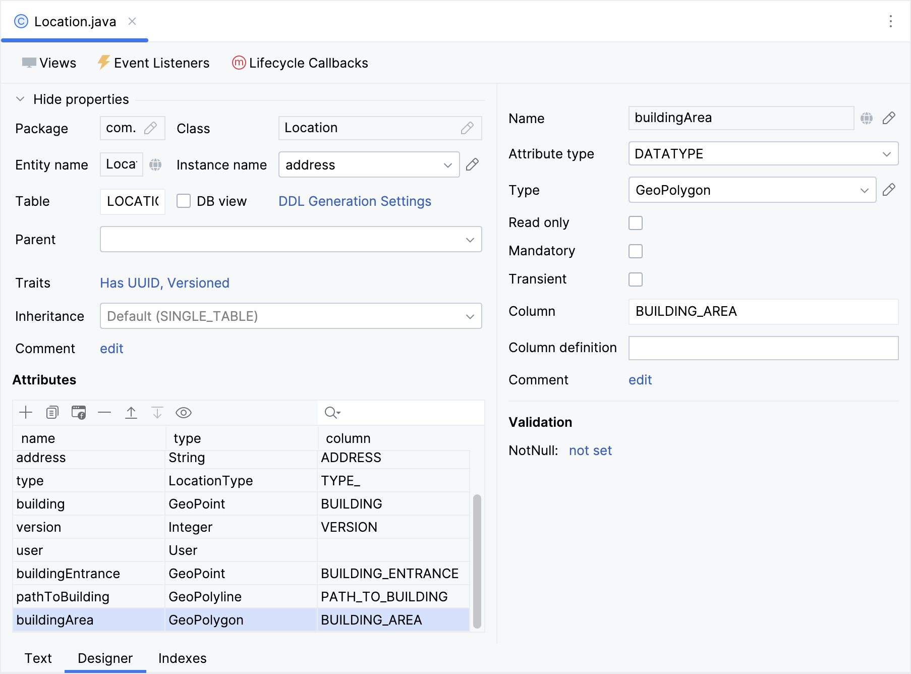
将这些属性添加至 Location.detail 视图。
为了简化我们的教程,这些新加的字段我们都用 UI 的文本控件。这些字段的值也可以从地图的点击事件中获取,与 maps:data-binding-map.adoc#saving-coordinates 类似。
下面是我们用到的示例数据:
-
Building:
POINT (13.347796079315284 52.55344847222085) -
Building entrance:
POINT (13.347860653822895 52.553536712270784) -
Path to building:
LINESTRING (13.346886063248354 52.553529790121985,
13.347394863347068 52.5532539371346, 13.347837668453902 52.55355180648286,
13.347860653822895 52.553536712270784)
-
Building area:
POLYGON ((13.347878609736783 52.553551482547135,
13.34795260252847 52.55350646966119,
13.347713548893793 52.55334632728869,
13.347640979040412 52.553390474703775,
13.347878609736783 52.553551482547135))
添加矢量层
地图中需要用矢量层处理几何图形。一个地图中可以添加多个矢量层。
因此,为了演示地图中的点、线段和多边形,我们需要为地图添加矢量层。
打开 location-lookup-view.xml 为 地理对象 的每个地理属性创建单独的矢量层和矢量数据源。为矢量数据源指定 dataContainer 和 property 属性:
<maps:geoMap id="map" ...>
    ...
    <maps:layers>
        <maps:tile>
            <maps:osmSource/>
        </maps:tile>
        <maps:vector id="dataVectorLayer">
            <maps:dataVectorSource id="buildingSource"
                                   dataContainer="locationsDc"
                                   property="building"/>
        </maps:vector>
        <maps:vector id="vectorLayerArea">
            <maps:dataVectorSource id="areaSource"
                                   dataContainer="locationsDc"
                                   property="buildingArea"/>
        </maps:vector>
        <maps:vector id="vectorLayerPath">
            <maps:dataVectorSource id="pathSource"
                                   dataContainer="locationsDc"
                                   property="pathToBuilding"/>
        </maps:vector>
        <maps:vector id="vectorLayerEntrance">
            <maps:dataVectorSource id="entranceSource"
                                   dataContainer="locationsDc"
                                   property="buildingEntrance"/>
        </maps:vector>
    </maps:layers>
</maps:geoMap>
添加点
在 LocationLookupView 视图控制器中,添加一个新方法:
@ViewComponent("map.vectorLayerEntrance.entranceSource")
private DataVectorSource<Location> entranceSource;

private void initBuildingEntranceSource() {
    entranceSource.setStyleProvider((location -> (1)
            new Style()
                    .withImage(new CircleStyle()
                            .withRadius(4)
                            .withFill(new Fill("#000000"))
                            .withStroke(new Stroke()
                                    .withWidth(2d)
                                    .withColor("#ffffff")))));
}| 1 | 配置一个 styleProvider,使用自定义的样式显示一个点。 |
添加多段线
在 LocationLookupView 视图控制器中,添加一个 initPathToBuildingSource():
@ViewComponent("map.vectorLayerPath.pathSource")
private DataVectorSource<Location> pathSource;

private void initPathToBuildingSource() {
    pathSource.setStyleProvider(location -> (1)
            new Style()
                    .withStroke(new Stroke()
                            .withWidth(2d)
                            .withColor("#000000")
                            .withLineDash(List.of(0.2, 8d, 0.8d))));
}| 1 | 配置一个 styleProvider,使用自定义的线段样式显示一条多段线。 |
添加多边形
在 LocationLookupView 视图控制器中,添加一个 initBuildingAreaSource():
@ViewComponent("map.vectorLayerArea.areaSource")
private DataVectorSource<Location> areaSource;

private void initBuildingAreaSource() {
    areaSource.setStyleProvider(location -> { (1)
        String fillColor = location.getType() == LocationType.COWORKING
                ? "rgba(52, 216, 0, 0.2)"
                : "rgba(1, 147, 154, 0.2)";
        String strokeColor = location.getType() == LocationType.COWORKING
                ? "#228D00"
                : "#123EAB";
        return new Style()
                .withFill(new Fill(fillColor))
                .withStroke(new Stroke()
                        .withWidth(2d)
                        .withColor(strokeColor));
    });
}| 1 | 配置一个 styleProvider,使用自定义的线段样式显示一个多边形。填充的颜色和边框的颜色依据类型而变化。 |
在 onInit() 中调用创建的方法:
@Subscribe
public void onInit(final InitEvent event) {
initBuildingAreaSource();
initBuildingEntranceSource();
initPathToBuildingSource();
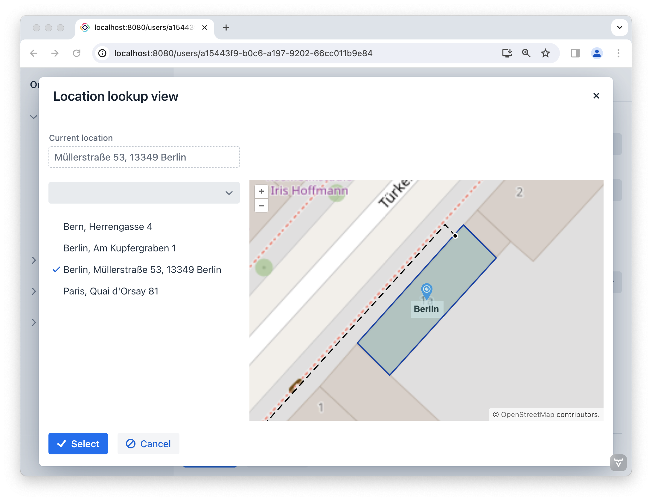
}启动应用程序查看新添加的功能。当选择位置时,地图会放大,并以选择的位置坐标为中心。
建筑物的入口在地图中以黑色圆点表示,路径以虚线段表示,多边形描绘建筑物的边界。